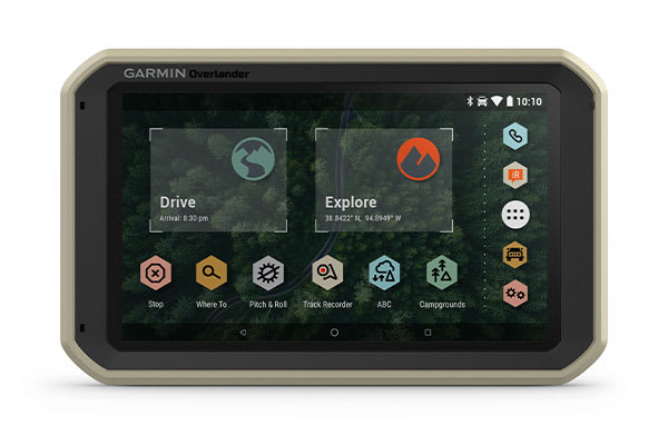
Use the Garmin Explore app to synchronize routes, tracks, and waypoints between the Overlander™ satellite navigation, smartphone, and desktop devices. Easily import and export GPX files in Garmin Explore – even in offline mode.
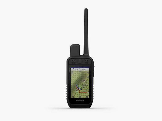
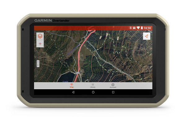
The Overlander comes with pre-installed topographic data for Europe, the Middle East, and Africa. Download additional topographic maps worldwide to the internal storage of 64 GB.
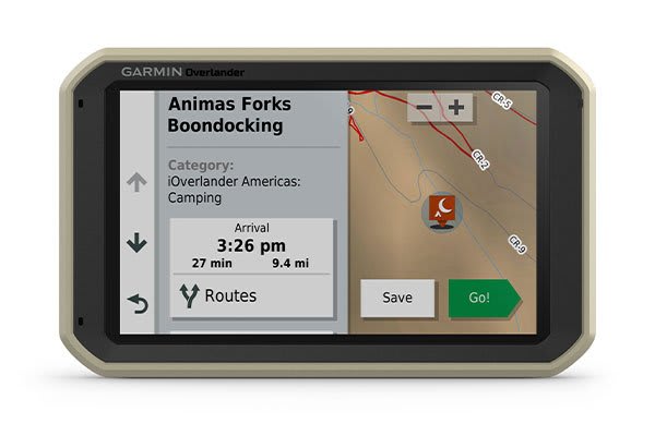
With the pre-installed POIs (Points of Interest) from iOverlander™, ACSI™, Campercontact™, and Trailer's PARK™, you can find well-known, remote, or hard-to-find campsites even without mobile reception.
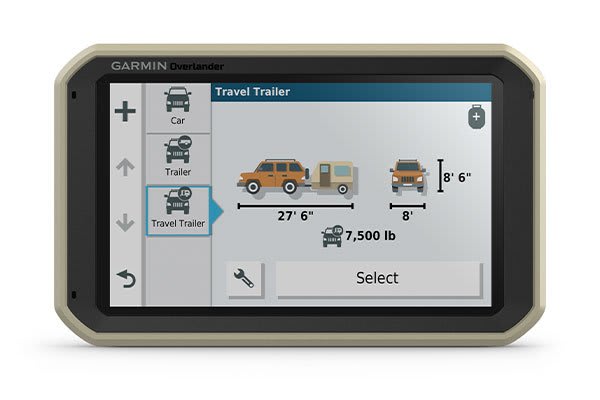
Adjust the street navigation to the size and weight of the off-road vehicle and also receive warnings about upcoming bridge heights, weight restrictions, sharp turns, steep inclines, descents, and much more.
GPS, GLONASS, and GALILEO satellite navigation reliably guide you to your destination even in difficult terrain and under the harshest conditions.
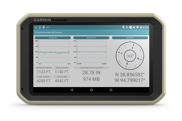
Your entire overlanding equipment, including an integrated compass, an altimeter, and a barometer, is now consolidated into one device.
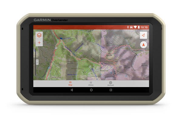
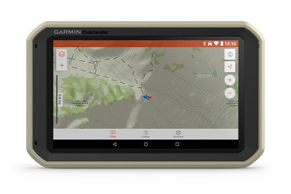
On the 7″ color touchscreen, turn-by-turn directions for street navigation in Europe, the Middle East, and Africa are displayed. Additionally, topographic maps for off-road navigation are also available. The internal storage of 64 GB allows for the download of additional TOPO maps.
The
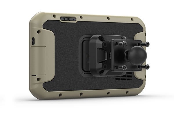
development of the Overlander was carried out according to US military standard 810 with
regard to thermal performance and shock resistance. The magnetic
mount with power supply, suction cup mount, and 1″ RAM ball adapter
with AMPS plate allows for flexible mounting.
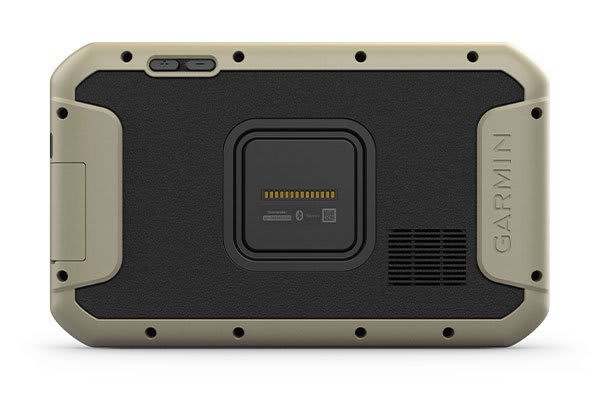
In the development of this important part of the overlanding equipment, care was taken from the circuit board onwards to ensure that everything withstands dust and extreme temperatures.
Verwende die Garmin Explore App kannst du Routen, Tracks und Wegpunkte zwischen dem Overlander™-Satellitennavi,
Smartphone und Desktop-Geräten synchronisieren. Importiere und
exportiere problemlos GPX-Dateien in Garmin Explore – auch im
Offline-Modus.
Auf
dem Overlander sind topografische Daten für Europa, den Nahen Osten und
Afrika vorinstalliert. Lade weltweit zusätzliche topografische Karten
in den internen Speicher von 64 GB herunter.
Mit den vorinstallierten POIs (Points of Interest) von iOverlander™, ACSI™, Campercontact™ und Trailer's PARK™, findest du auch ohne Mobilfunkempfang bekannte, abgelegene oder schwer auffindbare Campingplätze.
Passe
die Straßennavigation an die Größe und das Gewicht des Geländefahrzeugs
an und erhalte außerdem Warnungen vor den nächsten Brückenhöhen,
Gewichtsbeschränkungen, scharfen Kurven, starken Steigungen, Gefällen
u.v.m.
GPS,
GLONASS und GALILEO Satellitennavigation bringen dich auch in
schwierigem Gelände und unter widrigsten Bedingungen zuverlässig bis zu
deinem Ziel.
Deine
gesamte Overlanding-Ausrüstung, darunter ein integrierter Kompass, ein
Höhenmesser und ein Barometer, ist jetzt in einem Gerät zusammengefasst.
Auf
dem 7″ großen Farb-Touchscreen werden Abbiegehinweise für die
Straßennavigation in Europa, im Nahen Osten und in Afrika angezeigt.
Zudem auch topografische Karten für die Navigation im Gelände. Der
interne Speicher von 64 GB ermöglicht den Download zusätzlicher
TOPO-Karten.
Die
Entwicklung des Overlander erfolgte nach US-Militärstandard 810 im
Hinblick auf thermische Leistung und Stoßfestigkeit. Die magnetische
Halterung mit Stromversorgung, Saugnapfhalterung und 1″ RAM Kugeladapter
mit AMPS-Platte ermöglicht eine flexible Montage.
Bei
der Entwicklung dieses wichtigen Teils der Overlanding-Ausrüstung wurde
schon bei der Platine darauf geachtet, dass alles Staub und extremen
Temperaturen widersteht.