Note:
The item is located abroad. Please note that delivery conditions, shipping times, and/or the purchase process may differ.
```html
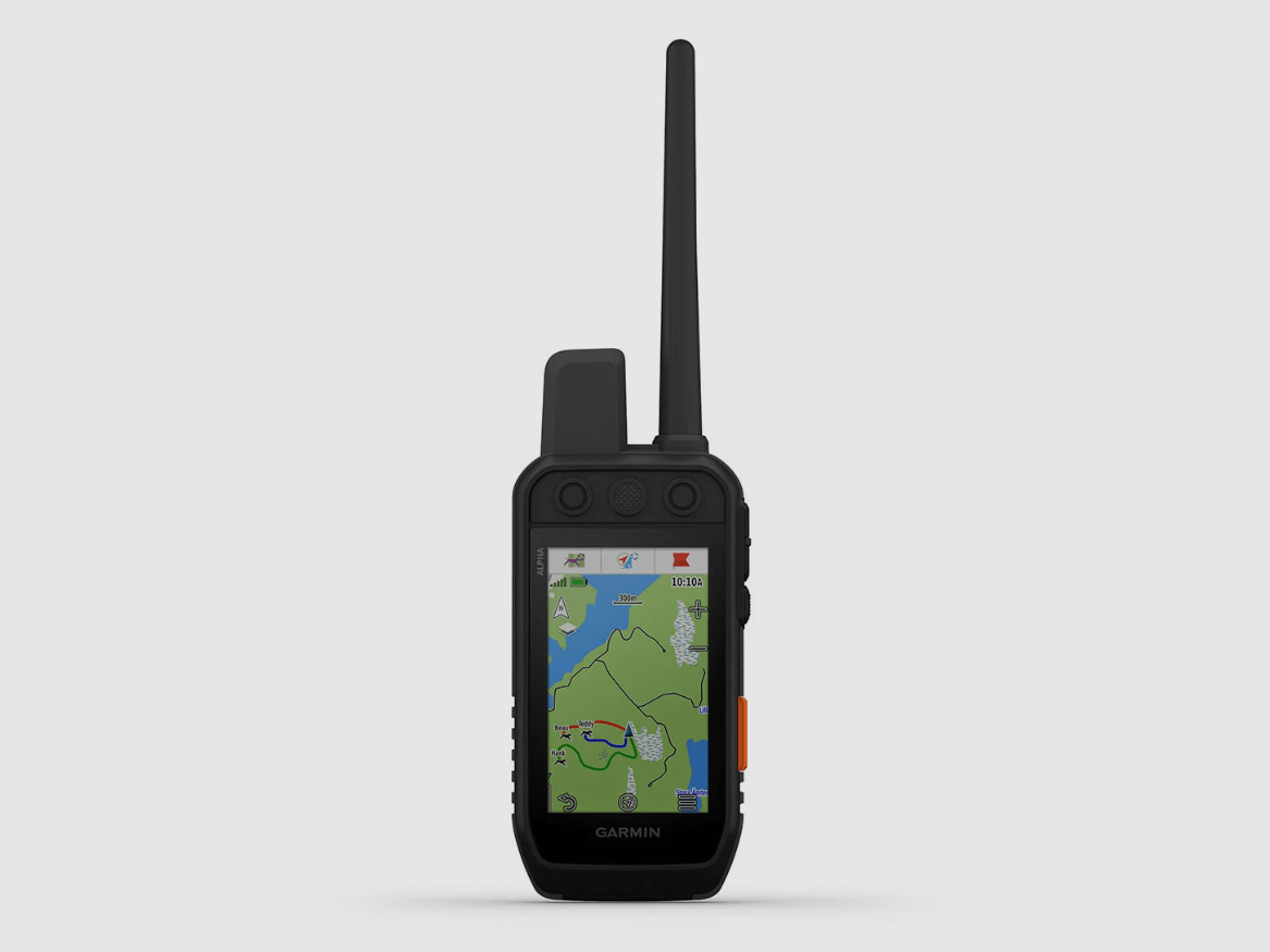
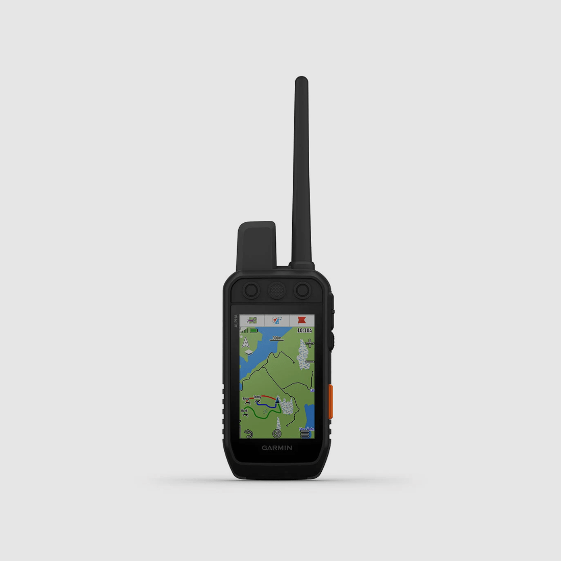
Garmin Alpha 300i K
A STRONG CONNECTION
No matter where you go hunting - you need reliable equipment along with your dogs. Track your dogs in the field1 with the Alpha® 300i K handheld device. It features a clear, 3.5-inch touchscreen display, a user-friendly design with 6 buttons, and supports inReach® satellite communication.
RESPONSIVE TOUCH DISPLAY AND BUTTONS
RELIABLE DOG TRACKING
COMMUNICATE VIA INREACH SATELLITE TECHNOLOGY2
UP TO 50 HOURS BATTERY LIFE WITH ACTIVATED INREACH TECHNOLOGY
TOPOACTIVE MAPS AND SATELLITE IMAGERY
INNOVATIVE FEATURES
CLEAR TOUCH DISPLAY
On an even brighter, 3.5-inch display with an update rate of up to 5 seconds, you can view maps and reliably track your dogs. The responsive touchscreen is easy to read in various lighting conditions and can be operated with gloves.
CHANNEL VIEW
See at a glance how many Garmin devices are active in your vicinity on which radio channel. Choose less used channels for your dog collars to avoid interference.
INREACH TECHNOLOGY
In an emergency, send an interactive SOS distress signal using inReach satellite technology. Stay in touch with friends and family and exchange messages when no mobile service is available. You can also track your position and share it with your family at home or others in the field.
TRACK MULTIPLE DOGS
Monitor the position of up to 20 dogs with your compatible dog collars. The range is up to 10 kilometers.
SATELLITE IMAGERY
Download satellite imagery to your handheld device via Wi-Fi and view the terrain from above. This makes navigation and finding suitable habitats for your game easier.
KEEP AN EYE ON YOUR DOGS
FEATURES OF THE HANDHELD DEVICE
LONG BATTERY LIFE
The rechargeable battery lasts up to 55 hours—or 50 hours with inReach technology activated.
GROUP MANAGEMENT
Save time at the start of the hunt by setting up groups of dogs and people.
MONITORING DOGS
You can see when a dog has pointed or is on point.
GARMIN EXPLORE™ APP
When paired with the Garmin Explore app, you can view the entire hunt and more.
BACKWARD COMPATIBILITY
Easily pair the handheld device with certain K-series collars.
DOG LIST
Store up to 250 dogs for easy switching between active collars in the field.
DOG DATA
View important dog data directly on the dog information page, such as distance, speed, and time in the field1.
FEATURES OF INREACH TECHNOLOGY
GLOBAL REACH
Messages, SOS distress signals, and location data are transmitted via the global Iridium satellite network2.
ALWAYS UP-TO-DATE
Receive detailed weather reports on your handheld device with the Garmin Explore app2.
GARMIN EXPLORE™ APP
When paired with the Garmin Explore app, you can quickly and easily send messages via satellite2.
MAPSHARE™ TOUR PAGE
Provide friends and family with an easy way to see your progress, display your GPS location, and exchange messages while you're on the go2.
NAVIGATION FEATURES
MULTI-SATELLITE RECEPTION
Utilize multiple global navigation satellite systems for more precise positioning in challenging environments.
PRO VIEW COMPASS
This simple, clear view displays the direction, distance, and status of the dogs.
TOPOACTIVE MAPS
Get a detailed view of terrain contours, topographic elevations, peaks, parks, and more.
PREMIUM MAP FEATURES
Subscribe to Outdoor Maps+ and receive public land information, enhanced topographic maps, landowner names, and more.
ALTIMETER
The barometric altimeter helps you accurately monitor ascents and descents.
3-AXIS COMPASS
Use the electronic 3-axis compass with tilt compensation for navigation—whether in motion or stationary.
Technical Specifications:
DIMENSIONS
6.8 x 16.2 x 3.4 cm (2.7 x 6.4 x 1.3 inches) *Dimensions do not include the antenna
WEIGHT
280g with standard antenna and battery
WATERPROOFING
IPX7
TOUCHSCREEN
DISPLAY TYPE
Transflective TFT color touchscreen
DISPLAY SIZE, W X H
(W x H) 4.7 x 7.7 cm; 88.9 mm diagonal (3.5 inches)
DISPLAY RESOLUTION, W X H
282 x 470 pixels
BATTERY
Rechargeable
```
(Show description in original language)
EINE STARKE VERBINDUNG
Ganz gleich, wo du jagen gehst - du benötigst zusammen mit deinen Hunden eine zuverlässige Ausrüstung. Orte deine Hunde im Feld1 mit dem Alpha® 300i K Handgerät. Es hat ein klares, 3,5-Zoll großes Touchdisplay, ein benutzerfreundliches Design mit 6 Tasten und unterstützt die inReach® Satellitenkommunikation.
REAKTIONSSCHNELLES TOUCHDISPLAY UND TASTEN
ZUVERLÄSSIGE HUNDEORTUNG
KOMMUNIZIERE ÜBER DIE INREACH SATELLITENTECHNOLOGIE2
BIS ZU 50 STUNDEN AKKULAUFZEIT MIT AKTIVIERTER INREACH-TECHNOLOGIE
TOPOACTIVE-KARTEN UND SATELLITENBILDER
INNOVATIVE FUNKTIONEN
KLARES TOUCHSDISPLAY
Auf einem noch helleren, 3,5-Zoll großen Display mit einer Aktualisierungsrate von bis zu 5 Sekunden kannst du Karten anzeigen und deine Hunde zuverlässig orten. Das reaktionsschnelle Touchdisplay ist bei verschiedenen Lichtverhältnissen gut lesbar und auch mit Handschuhen bedienbar.
CHANNEL VIEW
Sieh auf einen Blick, wie viele Garmin Geräte in deiner Umgebung auf welchem Funkkanal aktiv sind. Wähle weniger genutzte Kanäle für deine Hundehalsbänder, um Störungen zu vermeiden.
INREACH-TECHNOLOGIE
Sende im Notfall mithilfe der inReach-Satellitentechnologie einen interaktiven SOS-Notruf ab. Bleibe mit Freund*innen und Familie in Kontakt und tausche Nachrichten aus, wenn kein Mobilfunk verfügbar ist. Außerdem kannst du deine Position verfolgen und sie mit deiner Familie zuhause oder mit anderen im Feld teilen.
ORTE MEHRERE HUNDE
Überwache die Position von bis zu 20 Hunden mit deinen kompatiblen Hundehalsbändern. Die Reichweite beträgt dabei bis zu 10 Kilometer.
SATELLITENBILDER
Lade Satellitenbilder per WLAN auf dein Handgerät herunter und sieh dir das Gelände von oben an. Das erleichtert die Navigation und die Suche nach geeigneten Lebensräumen für deine Beute.
BEHALTE DEINE HUNDE IM BLICK
FUNKTIONEN DES HANDGERÄTS
LANGE AKKULAUFZEIT
Der auswechselbare Akku hält bis zu 55 Stunden— oder 50 Stunden bei aktivierter inReach-Technologie.
GRUPPENVERWALTUNG
Spare am Anfang der Jagd Zeit, wenn du Gruppen von Hunden und Personen einrichtest.
ÜBERWACHEN DER HUNDE
Du kannst sehen, wenn ein Hund Beute gestellt hat oder vorsteht.
GARMIN EXPLORE™ APP
Bei Kopplung mit der Garmin Explore App kannst du die gesamte Jagd u.v.m. anzeigen.
ABWÄRTS-KOMPATIBILITÄT
Koppele das Handgerät mühelos mit bestimmten Halsbändern der K-Serie.
HUNDELISTE
Speichere bis zu 250 Hunde, um im Feld einfach zwischen aktiven Halsbändern zu wechseln.
HUNDEDATEN
Sieh dir direkt auf der Hundeinformationsseite wichtige Hundedaten an, beispielsweise Distanz, Geschwindigkeit und Zeit im Feld1.
FUNKTIONEN DER INREACH-TECHNOLOGIE
WELTWEIT ERREICHBAR
Nachrichten, SOS-Notrufe und Ortungsdaten werden über das globale Iridium-Satellitennetzwerk übertragen2.
IMMER UP-TO-DATE
Erhalte mit der Garmin Explore App detaillierte Wetterberichte auf deinem Handgerät2.
GARMIN EXPLORE™ APP
Bei Kopplung mit der Garmin Explore App kannst du schnell und einfach Nachrichten per Satellit senden2.
MAPSHARE™-TOURSEITE
Biete Freund*innen und Familie eine einfache Möglichkeit, deinen Fortschritt zu sehen, deine GPS-Position anzuzeigen und Nachrichten auszutauschen, während du unterwegs bist2.
NAVIGATIONSFUNKTIONEN
MULTI-SATELLITENEMPFANG
Nutze mehrere globale Navigations-Satellitensysteme, um in schwierigen Umgebungen eine präzisere Positionsfindung zu erhalten.
PRO VIEW KOMPASS
Bei dieser einfachen, übersichtlichen Ansicht werden die Richtung, Distanz und der Status der Hunde angezeigt.
TOPOACTIVE-KARTEN
Erhalte eine detaillierte Ansicht von Geländekonturen, topografischen Höhen, Gipfeln, Parks u.v.m.
PREMIUM-KARTENFUNKTIONEN
Abonniere Outdoor Maps+ und erhalte Public Land-Informationen, erweiterte topografische Karten, die Namen von Landbesitzern u.v.m.
HÖHENMESSER
Der barometrische Höhenmesser hilft dir dabei, den Aufstieg und Abstieg genau zu überwachen.
3-ACHSEN-KOMPASS
Nutze bei der Navigation den elektronischen 3-Achsen-Kompass mit Neigungskorrektur – ob in Bewegung oder im Stand.
Technische Daten:
ABMESSUNGEN
6,8 x 16,2 x 3,4 cm (2,7 x 6,4 x 1,3-Zoll) *Die Abmessungen umfassen nicht die Antenne
GEWICHT
280g mit Standardantenne und Akku
WASSERDICHTIGKEIT
IPX7
TOUCHSCREEN
ANZEIGETYP
Transflektives TFT Farb-Touchdisplay
ANZEIGEGRÖSSE, B X
(B x H) 4,7 x 7,7 cm; 88,9 mm Diagonale (3,5-Zoll)
ANZEIGEAUFLÖSUNG, B X H
282 x 470 Pixel
BATTERIE
Aufladbarer Lithium Ionen Akku