Note:
The item location is abroad. Please note that this may affect delivery conditions, shipping times, and/or the purchasing process.
```html
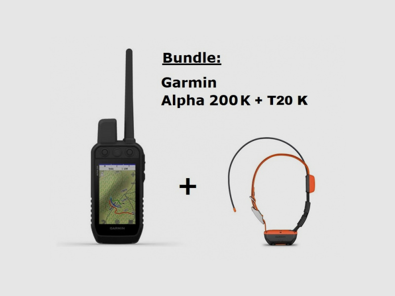
Garmin Alpha K200 / Alpha T20K GPS Dog Tracking SET!
No licensing required!
For this device, due to a new transmission frequency, no local licensing is needed anymore. Therefore, there are NO follow-up costs from the Federal Network Agency.
Details:
Garmin Alpha 200 K handheld device
STRONGLY CONNECTED.
Keep an eye on your dogs - With the Alpha® 200 K system, equipped with a 3.50″ large, capacitive, and sunlight-readable display and a user-friendly design with six buttons1.
Simple and user-friendly operation for quick tracking.
Track your dogs in the field.
Continue to store inactive dogs in the system and simplify your setup and management.
Use the best Garmin maps and sensors for navigation.
The replaceable battery lasts up to 20 hours.
Details:
TRACK MULTIPLE DOGS
Keep track of up to 20 dogs within a range of up to 10 kilometers (depending on the dog device) with an update rate of 5 seconds.
MANAGE YOUR DOGS
Continue to store inactive dogs in the dog list and manage active groups so you don't have to add and remove dogs for each hunt.
GARMIN EXPLORE™ APP
Pair with the Garmin Explore app on your compatible smartphone to view real-time dog tracking information, save collections of dog tracks, and replay tracks to see exactly what happened during the hunt.
COMPASS WITH PRO VIEW
The Pro view shows you at a glance both the direction and distance of your dogs as well as their current behavior.
MULTI-SATELLITE SUPPORT
Utilize multiple global navigation satellite systems (GPS and Galileo) to track your dogs with higher accuracy than using GPS alone.
TOPOACTIVE EUROPE MAPS
Our pre-installed TopoActive Europe maps provide detailed views of terrain contours, topographic elevations, peaks, parks, coastlines, rivers, lakes, and geographical points.
BIRDSEYE DIRECT
Download Birdseye satellite imagery directly to the handheld device for a realistic representation of the route, trailheads, clearings, and more.
NAVIGATION SENSORS
A barometric altimeter allows you to accurately monitor ascents and descents and see short-term trends in air pressure. With the built-in electronic 3-axis compass with tilt compensation, you won't lose your bearing - whether in motion or at rest.
EVERYTHING IN VIEW
On the 3.50″ large, capacitive, and sunlight-readable touchscreen, it's easy to see maps, dog data, and more, and to use the various functions - even with gloves.
ALWAYS ON THE MOVE
The replaceable battery lasts up to 20 hours, allowing you to spend plenty of time with your dogs in the field.
ADDITIONAL MAPS
Technical details:
Dimensions
6.80 x 16.20 x 3.40 cm (2.70 x 6.40 x 1.30″) * Dimensions do not include the antenna
Touchscreen
Display size, W x H
(W x H) 4.70 x 7.70 cm (1.80″ x 3.0″); 88.90 mm (3.50″) diagonal
Display resolution, W x H
282 x 470 pixels
Display type
Transflective TFT color touchscreen
Weight
280 g (9.90 ounces) with standard antenna and battery
Battery
Rechargeable lithium-ion battery (included)
Battery life
Up to 20 hours
Water resistance
IPX7
Interface
USB (high speed)
Memory/Log
16 GB
Maps and storage
Pre-installed maps
Yes (TopoActive Europe)
Ability to add maps
Base map
Automatic routing (turn-by-turn directions on roads)
Yes (with optional maps for detailed road information)
BirdsEye
Yes, directly on the device (no annual subscription required)
Storage and power capacity
microSD™ card (not included)
Waypoints
10,000
Tracks
Simultaneously up to 20 dogs (K 5) and friends (Atemos 100 and Alpha 200 K)
Track recording
20,000 points, 200 saved GPX tracks, 300 saved FIT activities
Routes
250
Saved contacts
250 dogs
Group management
Sensors
High-sensitivity GPS receiver
Barometric altimeter
Compass
Yes (3 axes, tilt compensation)
Outdoor recreation features
Sun and moon calendar
Compatible with custom maps
Radio function
Frequency band
MURS
Range
K 5, 10 kilometers
Outdoor applications
Compatible with the Garmin Explore™ app
Compatible with the Garmin Explore website
Connections
Wireless connectivity
Yes (Wi-Fi, Bluetooth®, and ANT+®)
```
(Show description in original language)
Garmin Alpha K200 / Alpha T20K GPS Hundeortung SET!
Keine Lizensierung notwendig!
Für diese Gerät benötigen Sie, aufgrund einer neuen Übertragungsfrequenz, keine örtliche Lizensierung mehr. Es folgen somit KEINE Folgekosten durch die Bundesnetzagentur an.
Details:
Garmin Alpha 200 K Handgerät
STARK VERBUNDEN.
Behalte deine Hunde im Blick - Mit dem Alpha® 200 K-System, ausgestattet mit einem 3,50″ großen, kapazitiven und bei Sonneneinstrahlung gut lesbaren Display und einem benutzerfreundlichen Design mit sechs Tasten1.
Einfache und benutzerfreundliche Bedienung für eine schnelle Ortung.
Orte deine Hunde im Feld.
Speichere inaktive Hunde weiterhin im System und vereinfache dir die Einrichtung und Verwaltung.
Nutze bei der Navigation die besten Garmin-Karten und -Sensoren.
Die auswechselbare Batterie hält bis zu 20 Stunden.
Details:
ORTE MEHRERE HUNDE
Behalte bis zu 20 Hunde im Umkreis von bis zu10 Kilometern (je nach Hundegerät) im Blick. Mit einer Aktualisierungsrate von 5 Sekunden.
VERWALTE DEINE HUNDE
Speichere inaktive Hunde weiterhin in der Hundeliste und verwalte aktive Gruppen, damit du Hunde nicht für jede Jagd hinzufügen und entfernen musst.
GARMIN EXPLORE™-APP
Nach Kopplung mit der Garmin Explore App auf deinem kompatiblen Smartphone, um Hundeortungsinformationen in Echtzeit anzuzeigen, Sammlungen von Hundetracks zu speichern und Tracks wiederzugeben, damit du genau sehen kannst, was auf der Jagd passiert ist.
KOMPASS MIT PRO ANSICHT
Die Pro Ansicht zeigt dir auf einen Blick sowohl die Richtung und die Entfernung deiner Hunde als auch deren aktuelles Verhalten.
MULTI-SATELLITEN-UNTERSTÜTZUNG
Nutze mehrere globale Navigationssatellitensysteme (GPS und Galileo), um deine Hunde mit einer höheren Genauigkeit zu orten als bei ausschließlicher Verwendung von GPS.
TOPOACTIVE EUROPA-KARTEN
Unsere vorinstallierten TopoActive Europa-Karten bieten detaillierte Ansichten von Geländekonturen, topografischen Höhen, Gipfeln, Parks, Küstenlinien, Flüssen, Seen und geografischen Punkten.
BIRDSEYE DIRECT
Download Birdseye-Satellitenbilder direkt auf das Handgerät herunter, um eine realitätsgetreue Darstellung der Route, den Anfängen von Wanderwegen, Lichtungen und mehr zu erhalten.
NAVIGATIONSSENSOREN
Ein barometrischer Höhenmesser ermöglicht es dir, den Aufstieg und Abstieg genau zu überwachen und kurzfristige Trends des Luftdrucks zu sehen. Mithilfe des integrierten elektronischen 3-Achsen-Kompasses mit Neigungskorrektur verlierst du deine Peilung nicht – weder in Bewegung noch im Stand.
ALLES IM BLICK
Auf dem 3,50″ großen, kapazitiven und bei Sonneneinstrahlung gut lesbaren Touchscreen ist es einfach, Karten, Hundedaten und mehr zu sehen und die verschiedenen Funktionen zu nutzen – sogar mit Handschuhen.
IMMER IN BEWEGUNG
Die auswechselbare Batterie hält bis zu 20 Stunden, sodass du viel Zeit mit deinen Hunden im Feld verbringen kannst.
ZUSÄTZLICHE KARTEN
Technische Details:
Abmessungen
6,80 x 16,20 x 3,40 cm (2,70 x 6,40 x 1,30″) * Die Abmessungen umfassen nicht die Antenne
Touchscreen
Anzeigegröße, B x H
(B x H) 4,70 x 7,70 cm (1,80″ x 3,0″); 88,90 mm (3,50″) Diagonale
Anzeigeauflösung, B x H
282 x 470 Pixel
Anzeigetyp
Transflektiver TFT-Farb-Touchscreen
Gewicht
280 g (9,90 Unzen) mit Standardantenne und Akku
Batterie
Aufladbarer Lithium-Ionen-Akku (im Lieferumfang enthalten)
Batterielaufzeit
Bis zu 20 Stunden
Wasserdichtigkeit
IPX7
Schnittstelle
USB (Highspeed)
Speicher/Protokoll
16 GB
Karten und Speicher
Vorinstallierte Karten
Ja (TopoActive Europa)
Möglichkeit, Karten hinzuzufügen
Basiskarte
Automatische Routenführung (Abbiegehinweise auf Straßen)
Ja (mit optionalen Karten für detaillierte Straßeninformationen)
BirdsEye
Ja, direkt auf das Gerät (kein Jahresabonnement erforderlich)
Speicher- und Leistungskapazität
microSD™-Karte (nicht im Lieferumfang enthalten)
Wegpunkte
10,000
Tracks
Gleichzeitig bis zu 20 Hunde (K 5) und Freunde (Atemos 100 und Alpha 200 K)
Trackaufzeichnung
20.000 Punkte, 200 gespeicherte GPX-Tracks, 300 gespeicherte FIT-Aktivitäten
Routen
250
Gespeicherte Kontakte
250 Hunde
Gruppenverwaltung
Sensoren
Hochempfindlicher GPS Empfänger
Barometrischer Höhenmesser
Kompass
Ja (3 Achsen, Neigungskorrektur)
Outdoor-Freizeitfunktionen
Sonnen- und Mondkalender
Kompatibel mit Custom Maps
Funkgerätfunktion
Frequenzband
MURS
Bereich
K 5, 10 Kilometer
Außenanwendungen
Kompatibel mit der Garmin Explore ™ App
Kompatibel mit der Garmin Explore-Website
Verbindungen
Drahtlose Konnektivität
Ja (WLAN, Bluetooth® und ANT+®)