-7 %
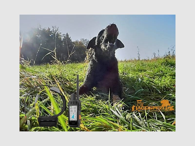


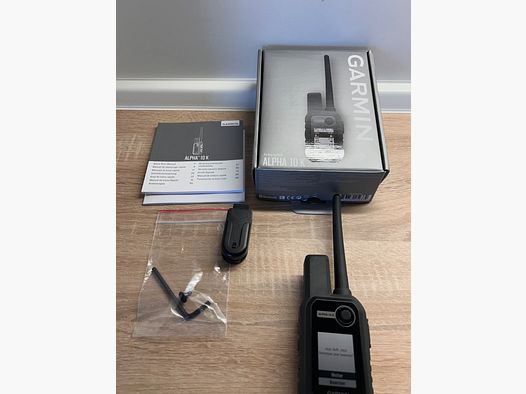
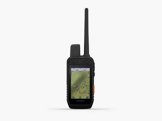
Alpha 200i K
Price at the dealer: 699 €. Converted at the ECB rate as of November 13, 2026.
No permit required (18+)
33699 Bielefeld, Germany
112
ID: 9508438
Purchase from outside the EU: The firearm goes through an importer in your country, the dealer handles the export.
How buying from Europe works
Shop safely with Gunfinder
Our AI-powered seller identity verification makes Gunfinder the safest marketplace online.
Learn more
Details
- Original language
- German
- Category
- Condition
- New
- Location
- 🇩🇪 33699 Bielefeld, Germany
- Availability
- In stock
Freshness
This listing is based on a mirrored offer, where the listing data was synced to us from a shop, dealer, or external marketplace. Please note that temporary price discrepancies may occur due to possible delays in data transmission.
- Source
- Jagdspezi
- Last checked with the dealer
- about 21 hours ago
Description
Note:
The item is located abroad. Please note that delivery conditions, shipping times, and/or the purchase process may differ.
Track your dogs with the Alpha 200i K, featuring inReach® Iridium satellite technology. The 3.5-inch touchscreen with buttons is easy to read, even in sunlight.
Simple, user-friendly operation for quick tracking.
Track your dogs accurately.
Keep inactive dogs in the system and make setup and management easier.
With inReach technology, friends and family stay informed when there’s no cell signal (satellite subscription required).
Use the best Garmin maps and sensors on every hunt.
The battery lasts up to 20 hours, or up to 15 hours with inReach technology enabled.
Always keep an eye on your dogs.
TRACK MULTIPLE DOGS
Keep track of up to 20 dogs within a range of up to 10 kilometers (depending on the dog device), with a 5-second update rate. Pair the device with the K5 collar (available separately or as a bundle).
DOG LISTS/GROUP MANAGEMENT
Keep inactive dogs in the dog list and manage active groups, so you don’t have to add and remove dogs for every hunt. Pair the device with the K5 collar (available separately or as a bundle).
COMPASS WITH PRO VIEW
In Compass with Pro View mode, you can track your dogs at a glance. See their direction, distance, and status.
Navigate your surroundings.
MULTI-GNSS SUPPORT
Use multiple global navigation satellite systems (GPS and Galileo) to track your dogs more accurately than with GPS alone.
TOPOACTIVE EUROPE MAPS
Our preloaded TopoActive Europe maps provide detailed views of terrain contours, topographic elevations, peaks, parks, coastlines, rivers, lakes, and geographic points.
BIRDSEYE SATELLITE IMAGERY
Download BirdsEye satellite imagery directly to your handheld device for a realistic view of routes, trailheads, clearings, and more.
NAVIGATION SENSORS
A barometric altimeter lets you accurately monitor your ascent and descent and see short-term air pressure trends. The built-in 3-axis electronic compass with tilt compensation keeps you on course, whether you’re moving or standing still.
SEE EVERYTHING CLEARLY
The 3.5-inch touchscreen is easy to read in sunlight, making it easy to view maps, dog data, and more, and use the various features.
KEEP GOING
The replaceable battery lasts up to 20 hours, or up to 15 hours with inReach technology enabled.
ADDITIONAL MAPS
The microSD™ memory card slot lets you load additional maps, such as TOPO PRO maps (available separately).
Stay connected with inReach technology.
TWO-WAY MESSAGING
Exchange text messages with friends and family in the field, post on social media, or communicate with other inReach devices (satellite subscription required).
INTERACTIVE SOS
In an emergency, send an interactive SOS alert to GEOS, a professional, 24/7 global monitoring and rescue coordination center (satellite subscription required).
LOCATION SHARING
Track your location and share it with others at home or in the field, so they can view your progress or send a request to your device for your GPS location, and more (satellite subscription required).
IRIDIUM® SATELLITE NETWORK WITH 100% GLOBAL COVERAGE
Instead of relying on cell coverage, your messages, SOS alerts, and locations are transmitted over the global Iridium satellite network (satellite subscription required).
General
DIMENSIONS
6.8 x 16.2 x 3.4 cm (* Dimensions do not include the antenna)
TOUCHSCREEN
DISPLAY SIZE, W X H
4.7 x 7.7 cm (W x H); 88.9 mm (3
,5-inch diagonal
DISPLAY RESOLUTION, W X H
282 x 470 pixels
DISPLAY TYPE
Transflective TFT color touchscreen
WEIGHT
280 g with standard antenna and battery
BATTERY
Rechargeable lithium-ion battery (included)
BATTERY LIFE
Up to 20 hours; up to 15 hours with inReach® technology enabled
WATER RATING
IPX7
HIGH-SENSITIVITY GPS RECEIVER
INTERFACE
USB (High Speed)
MEMORY/LOG
16 GB
Maps and memory
PRELOADED MAPS
Yes (TopoActive Europe)
ABILITY TO ADD MAPS
BASEMAP
AUTOMATIC ROUTING (TURN-BY-TURN DIRECTIONS ON ROADS
Yes (with optional maps for detailed road information)
BIRDSEYE
Yes, directly to the device (no annual subscription required)
MEMORY AND STORAGE CAPACITY
microSD™ card (not included)
WAYPOINTS
10,000
TRACKS
Up to 20 dogs (K5) and friends (Atemos 100 and Alpha 200i K) simultaneously
TRACK RECORDING
20,000 points, 250 saved GPX tracks, 300 saved FIT activities
ROUTES
250
Sensors
BAROMETRIC ALTIMETER
COMPASS
Yes (3-axis, tilt-compensated)
Safety and tracking features
LIVETRACK
Yes (with Garmin Explore ™)
Outdoor recreation features
SUN AND MOON CALENDAR
CUSTOM MAPS COMPATIBLE
inReach® features
INTERACTIVE SOS ALERTS
TWO-WAY MESSAGING (SEND AND RECEIVE) VIA SMS AND EMAIL
LOCATION SHARING WITH ANOTHER INREACH DEVICE
VIRTUAL KEYBOARD FOR COMPOSING YOUR OWN MESSAGES
SEND WAYPOINTS TO MAPSHARE WHILE TRAVELING
SEND ROUTE SELECTION TO MAPSHARE WHILE TRAVELING
Two-way radio features
FREQUENCY BAND
VHF
RANGE
K5 10 kilometers
Outdoor applications
COMPATIBLE WITH THE GARMIN EXPLORE ™ APP
COMPATIBLE WITH THE GARMIN EXPLORE WEBSITE
Connections
WIRELESS CONNECTIVITY
Yes (Wi-Fi, Bluetooth® and ANT+®) (Show description in original language)
EINE STARKE VERBINDUNG.
Orte deine Hunde mit dem Alpha 200i K mit inReach®-Iridium-Satellitentechnologie. Das 3,5 Zoll große Touchdisplay mit Tasten ist auch bei Sonneneinstrahlung gut lesbar.
Einfache und benutzerfreundliche Bedienung für eine schnelle Ortung.
Orte deine Hunde präzise.
Speichere inaktive Hunde weiterhin im System und vereinfache dir die Einrichtung und Verwaltung.
Dank inReach-Technologie bleiben Freunde und Familie informiert, wenn kein Mobilfunksignal vorhanden ist (Satellitenabonnement erforderlich).
Nutze bei jeder Jagd die besten Garmin-Karten und -Sensoren.
Die Batterie hält bis zu 20 Stunden, bei aktivierter inReach-Technologie bis zu 15 Stunden.
Behalte deine Hunde stets im Blick.
ORTEN MEHRERER HUNDE
Behalte ein Auge auf bis zu 20 Hunde im Umkreis von bis zu 10 Kilometern (je nach Hundegerät) und mit einer Aktualisierungsrate von 5 Sekunden. Koppele das Gerät mit dem K5 Halsband (separat oder als Bundle erhältlich).
HUNDELISTEN/VERWALTUNG VON GRUPPEN
Speichere inaktive Hunde weiterhin in der Hundeliste und verwalte aktive Gruppen, damit du Hunde nicht für jede Jagd hinzufügen und entfernen musst. Koppele das Gerät mit dem K5 Halsband (separat oder als Bundle erhältlich).
KOMPASS MIT PRO ANSICHT
Im Modus für den Kompass mit Pro Ansicht kannst du auf einen Blick deine Hunde orten. Du siehst die Richtung und Distanz der Hunde sowie deren Status.
Navigation in der Umgebung.
MULTI-GNSS-UNTERSTÜTZUNG
Nutze mehrere globale Navigationssatellitensysteme (GPS und Galileo), um deine Hunde mit einer höheren Genauigkeit zu orten als bei ausschließlicher Verwendung von GPS.
TOPOACTIVE EUROPA-KARTEN
Unsere vorinstallierten TopoActive Europa-Karten bieten detaillierte Ansichten von Geländekonturen, topografischen Höhen, Gipfeln, Parks, Küstenlinien, Flüssen, Seen und geografischen Punkten.
BIRDSEYE SATELLITENBILDER
Lade dir die BirdsEye Satellitenbilder direkt auf das Handgerät herunter, um eine realitätsgetreue Darstellung der Route, den Anfängen von Wanderwegen, Lichtungen und mehr zu erhalten.
NAVIGATIONSSENSOREN
Ein barometrischer Höhenmesser ermöglicht es dir, den Aufstieg und Abstieg genau zu überwachen und kurzfristige Trends des Luftdrucks zu sehen. Mithilfe des integrierten elektronischen 3-Achsen-Kompasses mit Neigungskorrektur verlierst du nie deine Peilung – weder in Bewegung noch im Stand.
ALLES IM BLICK
Auf dem 3,5 Zoll großen und bei Sonneneinstrahlung gut lesbaren Touchscreen ist es einfach, Karten, Hundedaten und mehr zu sehen und die verschiedenen Funktionen zu nutzen.
IMMER IN BEWEGUNG
Die auswechselbare Batterie hält bis zu 20 Stunden, bei aktivierter inReach-Technologie bis zu 15 Stunden.
ZUSÄTZLICHE KARTEN
Dank des microSD™-Speicherkartensteckplatzes kannst du weitere Karten laden, z. B. TOPO PRO-Karten (separat erhältlich).
Bleibe in Verbindung dank inReach-Technologie.
ZWEI-WEGE-NACHRICHTENVERSAND
Tausche im Feld SMS-Nachrichten mit Freunden und Familie aus, veröffentliche Beiträgen auf sozialen Medien oder kommuniziere mit anderen inReach-Geräten (Satellitenabonnement erforderlich).
INTERAKTIVES SOS
Löse im Notfall einen interaktiven SOS-Notruf an GEOS aus – eine professionelle, rund um die Uhr besetzte globale Überwachungs- und Rettungszentrale (Satellitenabonnement erforderlich).
TEILEN VON POSITIONEN
Verfolge deine Position und teile sie mit anderen zu Hause oder im Feld, damit sie deinen Fortschritt anzeigen oder eine Anfrage zum Abruf deiner GPS-Position an dein Gerät senden können und mehr (Satellitenabonnement erforderlich).
IRIDIUM®-SATELLITENNETZWERK MIT 100 %IGER GLOBALER ABDECKUNG
Anstatt dich auf die Mobilfunkabdeckung zu verlassen, werden deine Nachrichten, SOS-Alarme und Positionen über das globale Iridium-Satellitennetzwerk übertragen (Satellitenabonnement erforderlich).
Allgemein
ABMESSUNGEN
6,8 x 16,2 x 3,4 cm (* Die Abmessungen umfassen nicht die Antenne)
TOUCHSCREEN
ANZEIGEGRÖSSE, B X
4,7 x 7,7 cm (B x H); 88,9 mm (3,5 Zoll) diagonal
ANZEIGEAUFLÖSUNG, B X H
282 x 470 Pixel
ANZEIGETYP
Transflektiver TFT-Farb-Touchscreen
GEWICHT
280 g mit Standardantenne und Akku
BATTERIE
Aufladbarer Lithium-Ionen-Akku (im Lieferumfang enthalten)
BATTERIELAUFZEIT
Bis zu 20 Stunden; bis zu 15 Stunden bei aktivierter inReach® Technologie
WASSERDICHTIGKEIT
IPX7
HOCHEMPFINDLICHER GPS EMPFÄNGER
SCHNITTSTELLE
USB (Highspeed)
SPEICHER/PROTOKOLL
16 GB
Karten und Speicher
VORINSTALLIERTE KARTEN
Ja (TopoActive Europa)
MÖGLICHKEIT, KARTEN HINZUZUFÜGEN
BASISKARTE
AUTOMATISCHE ROUTENFÜHRUNG (ABBIEGEHINWEISE AUF STRASSEN
Ja (mit optionalen Karten für detaillierte Straßeninformationen)
BIRDSEYE
Ja, direkt auf das Gerät (kein Jahresabonnement erforderlich)
SPEICHER- UND LEISTUNGSKAPAZITÄT
microSD™-Karte (nicht im Lieferumfang enthalten)
WEGPUNKTE
10.000
TRACKS
Gleichzeitig bis zu 20 Hunde (K5) und Freunde (Atemos 100 und Alpha 200i K)
TRACKAUFZEICHNUNG
20.000 Punkte, 250 gespeicherte GPX-Tracks, 300 gespeicherte FIT-Aktivitäten
ROUTEN
250
Sensoren
BAROMETRISCHER HÖHENMESSER
KOMPASS
Ja (3 Achsen, Neigungskorrektur)
Sicherheits- und Trackingfunktionen
LIVETRACK
Ja (mit Garmin Explore ™)
Outdoor-Freizeitfunktionen
SONNEN- UND MONDKALENDER
KOMPATIBEL MIT CUSTOM MAPS
inReach® Features
INTERAKTIVE SOS-NOTRUFE
NACHRICHTENAUSTAUSCH (SENDEN UND EMPFANGEN) ÜBER SMS UND EMAIL
AUSTAUSCH VON POSITIONEN MIT ANDEREM INREACH-GERÄT
VIRTUELLE TASTATUR ZUM VERFASSEN EIGENER NACHRICHTEN
SENDEN VON WEGPUNKTEN AN MAPSHARE WÄHREND DER REISE
SENDEN DER ROUTENAUSWAHL AN MAPSHARE WÄHREND DER REISE
Sprechfunkgerätfunktionen
FREQUENZBAND
VHF
BEREICH
K5 10 Kilometer
Außenanwendungen
KOMPATIBEL MIT DER GARMIN EXPLORE ™ APP
KOMPATIBEL MIT DER GARMIN EXPLORE-WEBSITE
Verbindungen
DRAHTLOSE KONNEKTIVITÄT
Ja (WLAN, Bluetooth® und ANT+®)
Orte deine Hunde mit dem Alpha 200i K mit inReach®-Iridium-Satellitentechnologie. Das 3,5 Zoll große Touchdisplay mit Tasten ist auch bei Sonneneinstrahlung gut lesbar.
Einfache und benutzerfreundliche Bedienung für eine schnelle Ortung.
Orte deine Hunde präzise.
Speichere inaktive Hunde weiterhin im System und vereinfache dir die Einrichtung und Verwaltung.
Dank inReach-Technologie bleiben Freunde und Familie informiert, wenn kein Mobilfunksignal vorhanden ist (Satellitenabonnement erforderlich).
Nutze bei jeder Jagd die besten Garmin-Karten und -Sensoren.
Die Batterie hält bis zu 20 Stunden, bei aktivierter inReach-Technologie bis zu 15 Stunden.
Behalte deine Hunde stets im Blick.
ORTEN MEHRERER HUNDE
Behalte ein Auge auf bis zu 20 Hunde im Umkreis von bis zu 10 Kilometern (je nach Hundegerät) und mit einer Aktualisierungsrate von 5 Sekunden. Koppele das Gerät mit dem K5 Halsband (separat oder als Bundle erhältlich).
HUNDELISTEN/VERWALTUNG VON GRUPPEN
Speichere inaktive Hunde weiterhin in der Hundeliste und verwalte aktive Gruppen, damit du Hunde nicht für jede Jagd hinzufügen und entfernen musst. Koppele das Gerät mit dem K5 Halsband (separat oder als Bundle erhältlich).
KOMPASS MIT PRO ANSICHT
Im Modus für den Kompass mit Pro Ansicht kannst du auf einen Blick deine Hunde orten. Du siehst die Richtung und Distanz der Hunde sowie deren Status.
Navigation in der Umgebung.
MULTI-GNSS-UNTERSTÜTZUNG
Nutze mehrere globale Navigationssatellitensysteme (GPS und Galileo), um deine Hunde mit einer höheren Genauigkeit zu orten als bei ausschließlicher Verwendung von GPS.
TOPOACTIVE EUROPA-KARTEN
Unsere vorinstallierten TopoActive Europa-Karten bieten detaillierte Ansichten von Geländekonturen, topografischen Höhen, Gipfeln, Parks, Küstenlinien, Flüssen, Seen und geografischen Punkten.
BIRDSEYE SATELLITENBILDER
Lade dir die BirdsEye Satellitenbilder direkt auf das Handgerät herunter, um eine realitätsgetreue Darstellung der Route, den Anfängen von Wanderwegen, Lichtungen und mehr zu erhalten.
NAVIGATIONSSENSOREN
Ein barometrischer Höhenmesser ermöglicht es dir, den Aufstieg und Abstieg genau zu überwachen und kurzfristige Trends des Luftdrucks zu sehen. Mithilfe des integrierten elektronischen 3-Achsen-Kompasses mit Neigungskorrektur verlierst du nie deine Peilung – weder in Bewegung noch im Stand.
ALLES IM BLICK
Auf dem 3,5 Zoll großen und bei Sonneneinstrahlung gut lesbaren Touchscreen ist es einfach, Karten, Hundedaten und mehr zu sehen und die verschiedenen Funktionen zu nutzen.
IMMER IN BEWEGUNG
Die auswechselbare Batterie hält bis zu 20 Stunden, bei aktivierter inReach-Technologie bis zu 15 Stunden.
ZUSÄTZLICHE KARTEN
Dank des microSD™-Speicherkartensteckplatzes kannst du weitere Karten laden, z. B. TOPO PRO-Karten (separat erhältlich).
Bleibe in Verbindung dank inReach-Technologie.
ZWEI-WEGE-NACHRICHTENVERSAND
Tausche im Feld SMS-Nachrichten mit Freunden und Familie aus, veröffentliche Beiträgen auf sozialen Medien oder kommuniziere mit anderen inReach-Geräten (Satellitenabonnement erforderlich).
INTERAKTIVES SOS
Löse im Notfall einen interaktiven SOS-Notruf an GEOS aus – eine professionelle, rund um die Uhr besetzte globale Überwachungs- und Rettungszentrale (Satellitenabonnement erforderlich).
TEILEN VON POSITIONEN
Verfolge deine Position und teile sie mit anderen zu Hause oder im Feld, damit sie deinen Fortschritt anzeigen oder eine Anfrage zum Abruf deiner GPS-Position an dein Gerät senden können und mehr (Satellitenabonnement erforderlich).
IRIDIUM®-SATELLITENNETZWERK MIT 100 %IGER GLOBALER ABDECKUNG
Anstatt dich auf die Mobilfunkabdeckung zu verlassen, werden deine Nachrichten, SOS-Alarme und Positionen über das globale Iridium-Satellitennetzwerk übertragen (Satellitenabonnement erforderlich).
Allgemein
ABMESSUNGEN
6,8 x 16,2 x 3,4 cm (* Die Abmessungen umfassen nicht die Antenne)
TOUCHSCREEN
ANZEIGEGRÖSSE, B X
4,7 x 7,7 cm (B x H); 88,9 mm (3,5 Zoll) diagonal
ANZEIGEAUFLÖSUNG, B X H
282 x 470 Pixel
ANZEIGETYP
Transflektiver TFT-Farb-Touchscreen
GEWICHT
280 g mit Standardantenne und Akku
BATTERIE
Aufladbarer Lithium-Ionen-Akku (im Lieferumfang enthalten)
BATTERIELAUFZEIT
Bis zu 20 Stunden; bis zu 15 Stunden bei aktivierter inReach® Technologie
WASSERDICHTIGKEIT
IPX7
HOCHEMPFINDLICHER GPS EMPFÄNGER
SCHNITTSTELLE
USB (Highspeed)
SPEICHER/PROTOKOLL
16 GB
Karten und Speicher
VORINSTALLIERTE KARTEN
Ja (TopoActive Europa)
MÖGLICHKEIT, KARTEN HINZUZUFÜGEN
BASISKARTE
AUTOMATISCHE ROUTENFÜHRUNG (ABBIEGEHINWEISE AUF STRASSEN
Ja (mit optionalen Karten für detaillierte Straßeninformationen)
BIRDSEYE
Ja, direkt auf das Gerät (kein Jahresabonnement erforderlich)
SPEICHER- UND LEISTUNGSKAPAZITÄT
microSD™-Karte (nicht im Lieferumfang enthalten)
WEGPUNKTE
10.000
TRACKS
Gleichzeitig bis zu 20 Hunde (K5) und Freunde (Atemos 100 und Alpha 200i K)
TRACKAUFZEICHNUNG
20.000 Punkte, 250 gespeicherte GPX-Tracks, 300 gespeicherte FIT-Aktivitäten
ROUTEN
250
Sensoren
BAROMETRISCHER HÖHENMESSER
KOMPASS
Ja (3 Achsen, Neigungskorrektur)
Sicherheits- und Trackingfunktionen
LIVETRACK
Ja (mit Garmin Explore ™)
Outdoor-Freizeitfunktionen
SONNEN- UND MONDKALENDER
KOMPATIBEL MIT CUSTOM MAPS
inReach® Features
INTERAKTIVE SOS-NOTRUFE
NACHRICHTENAUSTAUSCH (SENDEN UND EMPFANGEN) ÜBER SMS UND EMAIL
AUSTAUSCH VON POSITIONEN MIT ANDEREM INREACH-GERÄT
VIRTUELLE TASTATUR ZUM VERFASSEN EIGENER NACHRICHTEN
SENDEN VON WEGPUNKTEN AN MAPSHARE WÄHREND DER REISE
SENDEN DER ROUTENAUSWAHL AN MAPSHARE WÄHREND DER REISE
Sprechfunkgerätfunktionen
FREQUENZBAND
VHF
BEREICH
K5 10 Kilometer
Außenanwendungen
KOMPATIBEL MIT DER GARMIN EXPLORE ™ APP
KOMPATIBEL MIT DER GARMIN EXPLORE-WEBSITE
Verbindungen
DRAHTLOSE KONNEKTIVITÄT
Ja (WLAN, Bluetooth® und ANT+®)